AS OF AUGUST 4, 8 AM:

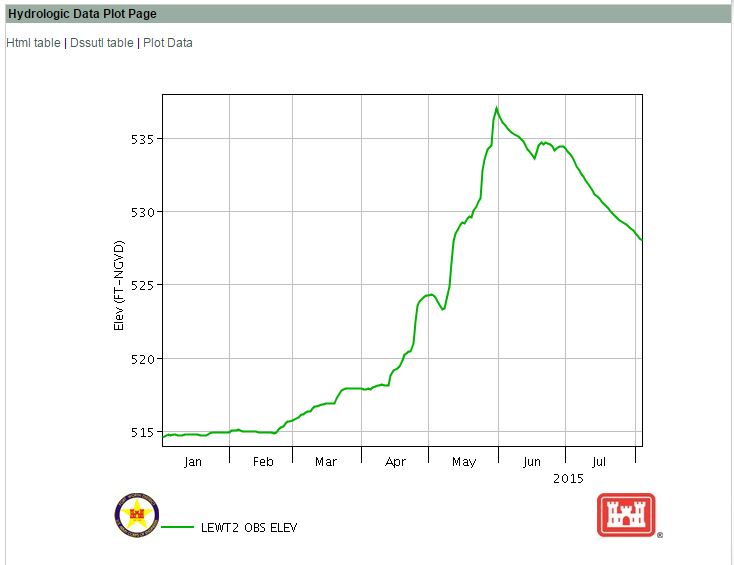
Water levels dipped below 528 this morning, putting us more than four feet below flood pool.

Between July 4 and August 4, lake levels dropped 5.39 feet,  an average of 2.11 inches per day.

Note that the speed at which the water is receding has slowed significantly. Since July 20, water levels have dropped only 1.13 inches a day on average.
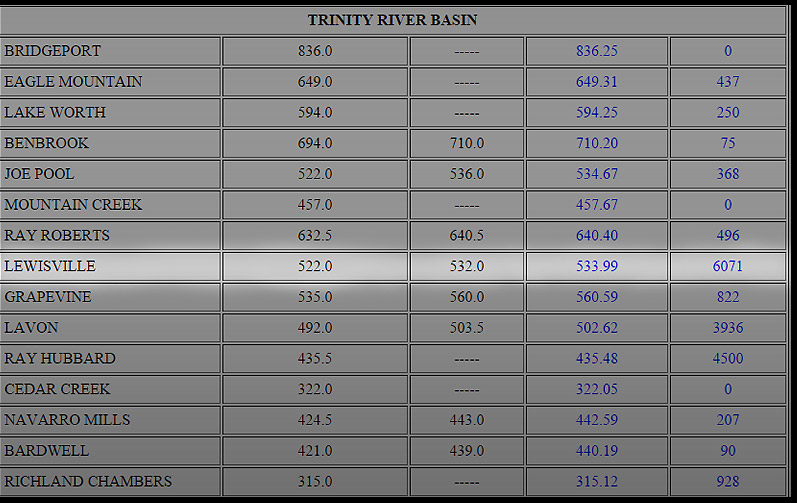
Lake Level:  527.95′

Feet above Conservation Pool:  5.95′

Feet over Flood Pool:  -4.05′

Corps is releasing 4,827 cubic feet per second

2015 08 water levels graph


AS OF JULY 30, 10 AM:

Water levels have dropped an average of 1.52 inches a day for a total of 1.14 feet since July 21. We are now more than three feet below flood pool.

Lake Level: 528.81′

Feet above Conservation Pool: 6.81′

Feet over Flood Pool: -3.19′

Corps is releasing 4,850 cubic feet per second


AS OF JULY 11, PER THE COMMODORE:

Great news for DCYC regarding our Corps of Engineers lease:

Just thought everyone could use a little good news… The lease renewal is up this month.  It runs us about 8k per year to lease the property. The good news is the CoE has come back with a 10 year lease for the same money as we are paying now… Maybe they felt sorry for us. Anyway very good news….

And even more good news:

Lake Lewisville has finally receded to 531.71 feet, 3.48 inches below the flood pool. We are now back in the high end of our conservation pool range.


AS OF 7:45 PM, JUNE 25:

At noon on the 17th, lake levels had dropped to 533.60. As a result of Tropical Depression Bill, lake levels rose 13.92 inches to max out at 534.76 between 6 AM and 3 PM on June 22. Since that time, levels have again dropped 6.36 inches.

Lake Level: 534.23′

Feet above Conservation Pool: 12.23′

Feet over Flood Pool: 2.23′

Corps is releasing 5,893 cubic feet per second

 harbor june 25 (1)

AS OF 1:30 PM, JUNE 18, PER THE FLEET CAPTAIN:

“As of Thursday morning June 18, the DCYC harbor has sustained major damage from tropical storm Bill. Docks 1, 2, & 3 have broken free and blown across the harbor to the southeast shore of our harbor. Many of the boats on these docks have sustained significant damage and a few have sunk. Likewise, many boats on dock 4 have also sustained damage and some are taking on water. Volunteers from the club have made every effort to secure the boats in the most immediate danger. All members with boats in slips on docks 4-6 should make time as soon as possible to inspect their boats and take measures to secure them further. At this time access to any of the remaining docks is limited. Members should coordinate with the Harbor Master before going out to the docks.Please plan on bringing new dock lines with you and please use the buddy system when at the docks.

The Board of Governors will be meeting soon to discuss our options and develop and game plan to begin the recovery process.  More information will follow soon.”

 docks 1 2 3

AS OF 4:45 PM, JUNE 17, PER THE DCYC CARETAKER:

Quick update from the lake. Surf is up! We’re in the back side of tropical storm Bill and the winds have kicked up to 30- 35 mph with higher gusts. We didn’t get alot of heavy rains and the lake doesn’t seem to have come up much, but more rain is forecasted and as you know lake levels continue to rise for hours after the rain stops. Docks and boats seem to be handling the storm with no apparent damage. Once the storm passes I encourage all boat owners check the status of there dock lines and boats. I will update you all of any changes that occur. I hope this helps. Aloha from the end of the road…

Mark Blanchard

 surf 2

surf 1

AS OF 11:45 PM, JUNE 16:

Lake levels continued to drop another .6 inches this afternoon and evening, in spite of the rain. Altogether, water levels have dropped 2.4 inches in the last 24 hours. 

Lake Level: 533.65′

Feet above Conservation Pool: 11.65′

Feet over Flood Pool: 1.65′

Corps is releasing 5,916 cubic feet per second


BRIDGE CLEARANCE, PER THE HARBOR MASTER

At the current 534.5′ Lewisville Lake Level, there is 49.5′ clearance.

How did we calculate this?  First, we took a look at the NTTA Engineering report, to get the official 52′ clearance above the spillway level, which is at 522′.  Then, we subtracted the height of the water above the spillway, 2.5′ (534.5-532).

From NTTA Engineering Report: ” The superstructure consists of 68 spans, each 120 feet in length, and a water craft passage span 360 feet in length. The water craft passage span provides a vertical clearance of 52 feet above the uncontrolled spillway elevation and a 350-foot horizontal clearance between span supports