Lake Level: 522.17′
Feet above Conservation Pool: .17′
Feet over Flood Pool: -9.83′
Corps is releasing 0 cubic feet per second
(Hope everyone enjoyed that soaking rain as much as I did. Wasn’t that lovely.)
Lake Level: 522.17′
Feet above Conservation Pool: .17′
Feet over Flood Pool: -9.83′
Corps is releasing 0 cubic feet per second
(Hope everyone enjoyed that soaking rain as much as I did. Wasn’t that lovely.)
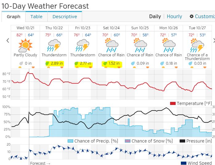
A flash flood watch was issued by the Fort Worth office of the National Weather Service at 3:38 pm.
_______________________________________
“Rain chances will increase significantly over the next 36 hours as an upper level storm system currently located over Arizona works its way east towards the Plains. Abundant Gulf moisture will be in place, along with a secondary slug of mid level Pacific moisture. High moisture levels combined with strong lift from the upper level system will lead to prolonged periods of moderate to heavy rain. A Flash Flood Watch has subsequently been issued for areas most likely to receive the heaviest rain, which includes all but the 2 southeastern-most county rows at this time. The Watch is in effect from Thursday Night though Saturday Night. At this time it appears that areas in the watch will receive anywhere from 2 to 5 inches, with locally higher amounts a good possibility. Please stay tuned to your latest weather forecast and alerts, especially those with weekend outdoor or travel plans.”
Lake Level: 521.15′
Feet above Conservation Pool: –.85′
Feet over Flood Pool: -10.85′
Corps is releasing 387 cubic feet per second
Tim Johnson has updated the Harbor Master’s page at the DCYC website. Check here if you are interested in buying or selling a slip: http://dcyc.org/page-1858304
